India uses satellite radar to monitor highway landslides
The Ministry of Road Transport and Highways is deploying InSAR-based satellite monitoring to detect ground movement and prevent landslide damage on critical highway stretches across India's most landslide-prone terrains.
NEW DELHI — The Ministry of Road Transport and Highways (MoRTH) is deploying satellite-based radar technology to monitor landslides on India’s most vulnerable highway stretches, as climate-related disasters become more frequent and threaten critical road infrastructure. The initiative centers on Interferometric Synthetic Aperture Radar (InSAR), a remote sensing technique that uses satellite signals to detect minute ground deformations. By measuring changes in the Earth’s surface over time, InSAR can identify slopes that are slowly shifting before they fail catastrophically.
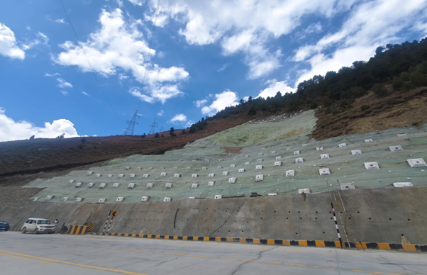
MoRTH officials have identified several high-risk corridors in the Himalayan and northeastern regions where landslides regularly disrupt traffic, damage road surfaces, and endanger lives. The technology is expected to provide continuous surveillance of these areas, allowing engineers to intervene before a major slide occurs. InSAR works by comparing radar images of the same location taken at different times. Differences in the signal phase reveal movements as small as a few millimeters.
This data can be processed to generate detailed maps of ground instability, which highway authorities can use to prioritize maintenance and reinforcement work. The shift toward technology-driven maintenance marks a departure from traditional reactive approaches, where repairs are carried out only after a landslide has already blocked a road or caused structural damage. Proactive monitoring is intended to reduce economic losses from prolonged closures and improve safety for commuters and freight transport.
India has one of the largest road networks in the world, and highways in mountainous states such as Uttarakhand, Himachal Pradesh, Sikkim, and Arunachal Pradesh are particularly susceptible to landslides during monsoon seasons. Climate change has intensified rainfall patterns, increasing the frequency and severity of slope failures. The InSAR-based system is part of a broader push by MoRTH to integrate modern technology into infrastructure management. The ministry has also explored the use of drones, ground sensors, and artificial intelligence for road inspection and maintenance, though the landslide monitoring program is among the most advanced applications currently being implemented.
Experts note that while InSAR is highly effective at detecting slow-moving landslides, it has limitations in areas with dense vegetation or steep terrain where radar signals can be distorted. To address this, the ministry is combining satellite data with field surveys and ground-based instruments to validate findings and improve accuracy. The deployment of InSAR monitoring is expected to be scaled up gradually, covering additional highway sections as the technology proves its reliability.
Officials have not disclosed the full budget or timeline for the program, but the initiative signals a long-term commitment to using space-based tools for civil infrastructure protection. For a country where landslides cause hundreds of deaths and billions of rupees in damage annually, the ability to predict and prevent such events could transform highway maintenance and disaster preparedness. The move also aligns with global trends, as transportation agencies in Japan, the United States, and Europe increasingly rely on satellite radar to manage geohazards along critical transport corridors.